Starting #ORPTrack - Satellite-tracking olive ridley sea turtles in the Indian Ocean around the Maldives
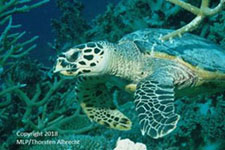
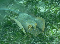
On Easter weekend 2022 an Olive Ridley Project team on the island of Coco Palm Dhuni Kolhu (Maldives) fitted a Telonics satellite tag, financed by Marine Life Protectors, to Autumn, a sub-adult female olive ridley turtle which had successfully recovered at the rescue centre and was ready for release. Autumn was released on Monday 18th from a beach, a first signal of her satellite transmitter was received during the following night.
 |
 |
 |
A few days later a first tracking map could be produced, showing Autumn's positions on her way leaving Baa Atoll, taking a curve around Goidhoo and then heading into a direction leading to North Male Atoll:
From end of April into May, Autumn crossed North Male Atoll (Kaafu). Usually olive ridley turtles live outside the atolls, but this observation shows that they do cross them occasionally.
Tracking map from May 19th, 2022: Autumn is now south of Sri Lanka and has traveled a distance of 1213 km in the first month after her release! Let's see where she is going next!
Autumn traveled on in an eastward direction, reaching the southern central part of the Gulf of Bengal in the first days of June. Unfortunately, her satellite transmitter stopped sending signals on June 10th, 2022.
Despite the far too early end of Autumn's tracking mission - after only 55 days - the Olive Ridley Project received a lot of interesting data about her, which allow valuable insights into the after-release-life of a former sea turtle rescue centre patient.
Just one example: Autumn's deepest recorded dive was down to a depth of 151 - 160 m, so we know she is able to reach typical diving depths of olive ridley sea turtles although she had lost one of her flippers because of entanglement in a ghost fishing net.
ORPTrack is a scientific research project that will help gain better understanding of the feeding habits of olive ridley sea turtles (Lepidochelys olivacea) in the Indian Ocean. Satellite tags will be attached to olive ridley turtle patients that are due to be released from
care at ORP's rescue centre in Baa Atoll. The satellite tags will allow to track the turtles for up to a year and the data gathered from these satellite tags will be consistently monitored, recorded and analysed. The aim is to answer two important questions to fill crucial gaps in sea turtle research and help the Olive Ridley Project plan for future conservation strategies.:
1. Where do olive ridley turtles go feeding in the Maldives and in the Indian Ocean as a whole?
2. What environmental factors make up a good feeding ground for olive ridleys?
The tracking project will also allow to get insights how well the rehabilitated former olive ridley turtle patients find back to their new life in freedom and will allow studying the diving behaviour of olive ridley sea turtles.
On May 23rd, 2022, the Olive Ridley Project released a second olive ridley sea turtle, named Pickle, with a satellite tag. Pickle's tag was funded to around 60% by Marine Life Protectors. Like Autumn, Pickle will help us better understand the habitats and the behaviour of olive ridley sea turtles in the Indian Ocean.
 |
For the first two weeks after her release Pickle seemed to be following Autumn, swimming into the same southeastern direction, but when she started reaching the Gulf of Bengal south of Sri Lanka, she suddenly turned around and headed back to the Maldives.
But Pickle didn't arrive in the Maldives so fast, instead she started swimming loops, which was really great to see because it might mean that she found an interesting feeding area there, in the east of the chain of atolls.
After her loops, Pickle turned into a southwestern direction, leading her to Huvadhoo Atoll in the south of Maldives.
Then it happened: No more signals were received from Pickle after July 31st, when she was somewhere southeast from Huvadhoo Atoll and northeast from Fuvamulah. We can only speculate about what happened, but it’s clear that we’ll never find out.
Nevertheless, the second tracking mission of olive ridley sea turtles in and around the Maldives was successful for 70 days, here are some general data about Pickle’s journey:
Total Distance Travelled: 2,481 km
Est. Average Speed Per Hour: 1.47 km
Average Daily Distance: 35.4 km
Deepest Dive: 81- 90 m
Compared to the first satellite-tracked olive ridley turtle, Autumn, which had been released from the rescue centre in Baa Atoll a month earlier, Pickle turned out not to be such a master diver, with her maximum diving depth of 81 – 90 m staying at around 50% of what Autumn was able to reach.
Could be quite interesting to compare these two very different diving behaviours with the medical record of each sea turtle from the time when they both were patients at the rescue centre.
For more information about the story of Pickle and her journey, visit Pickle on ORP's website.
How does sea turtle satellite tracking work? Here's a short basic introduction.
When the satellite-tagged sea turtle reaches the water surface for breathing, a sensor in the tag measures air instead of surrounding water and the transmitter will start emitting a signal in form of an electromagnetic wave of a defined, set wavelength or frequency. Only a very small portion of energy of this electromagnetic signal will be received by the antenna of a nearby research or communications satellite which compares the wavelength or frequency of the incoming signal with its internally stored information about the wavelength (frequency) of the turtle's transmitter.
Thus, the electronic systems onboard the satellite can decide whether a received signal is from the turtle's transmitter or has a different origin. If the signal is from the turtle, the GPS coordinates of the transmitter (turtle) are measured and stored in the satellite's electronic system.
At certain time intervals the satellite sends the measured and stored signal data information down to Earth, to a receiver station, from where they are sent to the researcher or research team.
It should be mentioned that the transmitter doesn't send a signal every time the sea turtle is on the water surface for breathing, to save energy of the battery. It is programmed to send signals only at certain times of a day.
All this sounds not so difficult and is relatively easy to understand, but the technical reality is different! We only like to give the following hint: The satellite has a relatively high speed relative to Earth and the turtle's position (see graphic). This means that the received electromagnetic wave hasn't the same wavelength or frequency as the emitted electromagnetic wave - due to a physical phenomenon called Doppler effect.
The incoming signal has a certain frequency shift or wavelength shift compared with the original frequency or wavelength of the emitted signal. That's why the satellite must constantly measure its own velocity relative to Earth, calculate by using this measured value its component of velocity which is directed directly towards the origin of the located signal (turtle) or the component which is directed directly away from the turtle, subtract or add the Doppler frequency shift
from or to the measured incoming frequency (depending on the direction of the satellite's velocity), and then the satellite's electronic systems will find by comparing: Yes, this signal is from the turtle.
The Doppler effect is only one of a lot of reasons why satellite-tracking is a relatively expensive method of biological research: Using high-tech and space technology is involved!
 |
After the process of data transfer you will have a point P on the surface of the Earth where the tracked turtle was located, with its polar coordinates lambda (which is the geographical longitude), phi (which is the geographical latitude), and its distance r to the Earth's centre M, which is approximately 6370 km. For further calculations it is possible to transform the polar coordinates (lambda, phi, r) of point P into coordinates (x, y, z) of a Cartesian coordinate system which has the same origin M as the polar coordinate system. This transformation would allow using the traditional formulas of vector calculation and linear algebra afterwards without inserting the polar coordinates into them. For example,
it is relatively easy to calculate the distance of two of these tracking points P1 and P2 on the Earth's surface which gives you an information about the minimum distance that the turtle has traveled between these two points.
(Please note: Within a certain accuracy you can use a sphere as a model for our Earth, we are not going to discuss or use its real shape of a rotating ellipsoid here.)
Over the time of a single sea turtle tracking process you will get a series of points, which are sometimes connected by a straight line for publication purposes, the tracking trajectory of the sea turtle.
We could say a lot more about data handling and evaluation of tracking data, to keep it short:
In the end, after having successfully tracked statistically enough olive ridley sea turtles in the Maldives, all location data will be fed into a habitat model or species distribution model (SDM), the aim of the ORP tracking study is developing a suitable two-dimensional habitat model for olive ridley sea turtles in the Indian Ocean around the Maldives.
The Olive Ridley Project will continue the satellite-tracking study about olive ridley sea turtles in the Indian Ocean region of the Maldives in 2023, beyond Autumn and Pickle.
Please visit their website and follow their social media posts for further news and updates about the progress of the satellite-tracking project.